Optimal Course running in Expedition

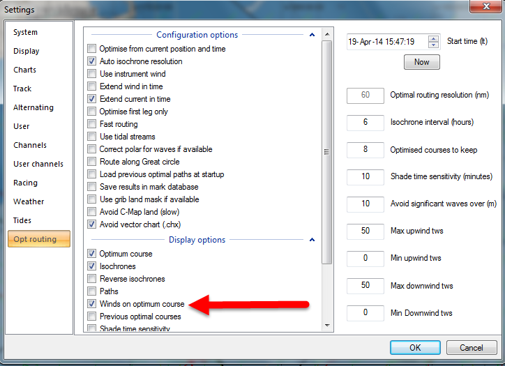
Prior to running an Optimal Course Expedition needs:

1) Boat Polars
2) A Course
3) Weather and Current Gribs

Here is the Weather settings window showing a GFS (wins) and RTOFS (current Gulf Stream) grib are both loaded, selected and ready for an optimal course to be run:

Optimal Course Weather GRIBS


Though…when you first select a GRIB for download via the direct connection mode it automatically loads and you don’t visit this screen.  It may be important to visit this screen to know with certainty what GRIBs are being included in the Optimal Course run…

Winds on Optimum Course

The “Winds on Optimum Course” feature is very useful.  I’m not sure why it isn’t set to on by default, but then there are a lotof really useful  things in Expedition that are not on by default.  This feature puts a wind barb onto the optimum course.  This is great for visualizing the course to be sailed and possible sail changes…etc…   The wind barb is what is FORECAST to be the wind when the boat gets to that location!  Just looking at these wind barbs down the optimal course gives a good sense of angles forecast to be sailing.

Winds on Optimum Course

Winds on Optimum Course Example

Dan and Bill are “Team Navigation” but…

Dan and Bill are “Team Navigation” but…

but I want to be sure I can speak intelligently with them and help in the dialog, preparation, learning… I’ve worked a little too hard today getting up to speed…lot of hours 0-:

2014-04-18_16-12-17

Refreshing on Expedition Software

One of the “problems” of not being a full-time professional sailor is you just don’t get out there enough to use all of the tools and stay fresh and current on them…  I’m working to refresh myself on how to use Expedition and all of it’s amazing features.  Actually not all, that won’t ever happen…but the BIG important ones like:

1) Basic Navigation
2) Strip Charting
3) Grib importing and interpreting
4) Loading base polars and using in conjunction with GRIBS for Optimal Routing.
5) Importing Geo-referenced images of the Gulf Stream
6) Loading a current GRIB to interact with the weather and polars for proper Optimal Routing.

And that’s just the basics 0-:

Here is a little video of me having some basic success: